
Wyoming Topographical Map
Static Wyoming Topo Map
This section features a topographical map of Wyoming as well as a map legend that specifies elevation ranges and indicates their corresponding map colors.

Map Legend |
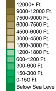 |
|
 |
Wyoming Topographical Features
Wyoming's highest mountain is Gannett Peak, whose peak is 13,785 feet above sea level. Other notable mountains in Wyoming include Grand Teton Mountain (13,766 feet). Wyoming's lowest elevation is 3,099 feet above sea level, at the Belle Fourche River. Wyoming landforms include the Great Plains in the east, which rise to the Bighorn Mountains and the Laramie Mountains, and finally to the Rocky Mountains in the west. The Great Divide Basin is located in south-central Wyoming. Major rivers in Wyoming include the Snake, Colorado, Green, and Columbia.Interactive Wyoming Topo Map
This section features a topographical map that can be zoomed and panned to show the entire State of Wyoming or a small portion of the state. To zoom in or out on the map, use the plus (+) button or the minus (-) button, respectively. To pan the map in any direction, simply swipe it or drag it in that direction. At high zoom levels, the contour lines on this Wyoming map can help outdoorsmen, land developers, and others to plan their routes and activities more efficiently.
Copyright © 2005-2026 State-Maps.org. All rights reserved.
Wyoming-Map.org is a State Maps reference source.
Wyoming-Map.org is a State Maps reference source.