Vermont Topographical Map
Static Vermont Topo Map
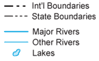
This section features a topographical map of Vermont as well as a map legend that specifies elevation ranges and indicates their corresponding map colors.

Map Legend |
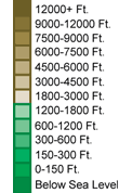 |
|
 |
Vermont Topographical Features
Vermont's highest mountain is Mount Mansfield, whose peak is 4,393 feet above sea level. Vermont's lowest elevation is 95 feet above sea level, at Lake Champlain. Vermont is noted for the Green Mountains which run north to south through the central portion of the state. In the west, a verdant plain runs along Lake Champlain. Major rivers in Vermont include the Lamoille, Winooski, Otter Creek, Poultney, and White.Interactive Vermont Topo Map
This section features a topographical map that can be zoomed and panned to show the entire State of Vermont or a small portion of the state. To zoom in or out on the map, use the plus (+) button or the minus (-) button, respectively. To pan the map in any direction, simply swipe it or drag it in that direction. At high zoom levels, the contour lines on this Vermont map can help outdoorsmen, land developers, and others to plan their routes and activities more efficiently.
Copyright © 2005-2026 State-Maps.org. All rights reserved.
Vermont-Map.org is a State Maps reference source.
Vermont-Map.org is a State Maps reference source.