
Utah Topographical Map
Static Utah Topo Map
This section features a topographical map of Utah as well as a map legend that specifies elevation ranges and indicates their corresponding map colors.

Map Legend |
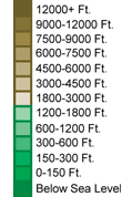 |
|
 |
Utah Topographical Features
Utah's highest mountain is Kings Peak, whose peak is 13,528 feet above sea level. Utah's lowest elevation is 2,000 feet above sea level, at Beaverdam Creek. Northwestern Utah consists of the Great Salt Lake and Desert while the Colorado Plateau and sandstone formations are found in southeastern Utah. The Wasatch and Uinta ranges of the Rockies dominate central and northeast Utah. Major rivers in Utah include the Colorado, Green, and Sevier.Interactive Utah Topo Map
This section features a topographical map that can be zoomed and panned to show the entire State of Utah or a small portion of the state. To zoom in or out on the map, use the plus (+) button or the minus (-) button, respectively. To pan the map in any direction, simply swipe it or drag it in that direction. At high zoom levels, the contour lines on this Utah map can help outdoorsmen, land developers, and others to plan their routes and activities more efficiently.
Copyright © 2005-2026 State-Maps.org. All rights reserved.
Utah-Map.org is a State Maps reference source.
Utah-Map.org is a State Maps reference source.