
California Topographical Map
Static California Topo Map
This section features a topographical map of California as well as a map legend that specifies elevation ranges and indicates their corresponding map colors.

Map Legend |
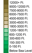 |
|
 |
California Topographical Features
California's highest mountain is Mount Whitney, whose peak is 14,491 feet above sea level. Other notable mountains in California include Mount Shasta (14,162 feet) and Lassen Peak (10,457 feet). California's lowest elevation is 282 feet below sea level, at Death Valley. California land features include the Coast Ranges near the Pacific coast, the the Klamath Mountains in the north, the Sierra Nevada to the east, the fertile Central Valley, and the Mohave desert in the southeast. Major rivers in California include the Colorado, Sacramento, Pit, and San Joaquin.Interactive California Topo Map
This section features a topographical map that can be zoomed and panned to show the entire State of California or a small portion of the state. To zoom in or out on the map, use the plus (+) button or the minus (-) button, respectively. To pan the map in any direction, simply swipe it or drag it in that direction. At high zoom levels, the contour lines on this California map can help outdoorsmen, land developers, and others to plan their routes and activities more efficiently.
Copyright © 2005-2026 State-Maps.org. All rights reserved.
California-Map.org is a State Maps reference source.
California-Map.org is a State Maps reference source.